Best Rivers for Pontoon Boating
America has some of the most beautiful and varied landscapes on the planet. There are natural hidden treasures all over the country that are accessible only by boat, and experiences that can only be had over the course of many days on the water. We've picked out five of the top rivers for pontoon boating across the country in hopes of inspiring owners to plan some exciting adventures this summer.
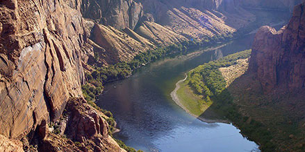
Colorado River: Davis Dam, AZ, to Parker Dam, CA
Near the tri-border area of Arizona, California and Nevada is an 88-mile-long segment of the Colorado River that attracts people from all over the world. From the southern point of Lake Mead National Recreation Area, boaters put in at Davis Dam and spend up to a week floating past stunning natural landscapes, beautiful beaches and historical sights, as well as parks, marinas and riverside nightlife. This trip can be as long or short as you want, with multiple places to take out along the way to Parker Dam.
The full 88-mile trip requires careful planning to safely pass through the more remote parts of the river. Between mid-March and the end of September, the current is just over two miles per hour. There are several lodging options along the way, from campgrounds to hotels. Land along this stretch of river is a mix of public and private, requiring you to pay attention to where you stop. There are established riverbank sites for casual recreation and some publicly owned areas that require permission or a reservation.
The Upper Mississippi River: Minneapolis, MN, to the Iowa border
The 160 miles of river from Minneapolis, MN, downstream to the Iowa border offers some uniquely American sights and experiences. You'll float past the Mississippi Gorge Regional Park, famous for its high limestone bluffs. The next 45 miles is in the tranquil beauty of the Mississippi National River and Recreation Area, dotted with parks and marinas. The rest of the trip to the Iowa border is a mixture of remote wilderness, sandy beaches and access to modern amenities.
Camping is allowed in designated areas, and there are marinas, campgrounds and hotels along the way. The Minnesota Department of Natural Resources publishes a helpful guide for this segment of river that includes section maps and points of interest.
Columbia and Snake Rivers: Clarkston, WA, to Portland, OR
Follow the route that the Lewis and Clark Expedition explored on their way to the Pacific and observe landscapes that have remained unchanged since then. From Clarkston, WA, the Snake River winds through 140 miles of picturesque canyon full of wildlife and Native American history before linking up with the Columbia River in Burbank, WA. From there it meanders another 200 miles to Portland, Oregon, passing by several historic towns along the historic Oregon Trail.
The Columbia is much wider than the Snake and has plenty of civilized amenities. After seeing majestic Mt. Hood tower over the horizon to your south, you'll pass into the Columbia River Gorge before arriving in Portland.
At over three hundred miles in total length, this trip is a serious undertaking that requires lots of preparation, but you'll consider it worth the effort as you camp, fish, sight-see, and reflect on the difficulties faced by those who travelled the same route in the past.
The Free Snake River Boating Guide is a user-maintained map and collection of information related to boating along the Snake River from Clarkston, WA to the Columbia River.
Illinois River: Chicago, IL, to Grafton, IL
This 327-mile trip is the best of both worlds, with the first leg offering amenities and nightlife in just the right places, and the second leg giving you a break from the trappings of modern life.
Starting in Chicago Harbor on Lake Michigan, boaters make their way through the heart of Chicago on the Chicago River, enjoying some of the best views of the city. As you continue, cityscape begins to alternate with nature preserves and suburbs until the Chicago River enters the Illinois River at the Dresden Island Lock. Here, the landscape becomes more agricultural.
Plan a stop in Peoria, where the riverside food and entertainment are renowned in the boating community, before embarking on the second half of the trip. After Peoria, the towns become smaller and further apart, separated by miles of vast fields and farmland, giving you plenty of time to contemplate the meaning of the word "heartland". Your journey ends at the Grafton Harbor Marina, mile marker 0 on the Illinois River, where it meets the Mississippi.
Lower Savannah River: Augusta, GA, to Savannah, GA
At nearly 200 miles in length, the lower Savannah River defines the border between Georgia and South Carolina and is little used by boaters or commerce. Winding past floodplains and plantations dating from before the Civil War, a one-way trip can take anywhere from seven to twelve hours. This stretch of river is one of the best-kept secret in Augusta.
The lower Savannah River was once a busy shipping route, dredged and maintained by the Army Corps of Engineers, but it was abandoned in 1979 and has remained largely untouched since then. Due to its wild nature, the river is perpetually changing and can present more of a challenge than many boaters are accustomed to. This stretch of river requires extra attentiveness and the ability to read charts correctly. Two sets of charts will be required, one for Augusta to Brier Creek and another from Brier Creek to the Atlantic.
It's recommended that boaters travel in groups. Most of the lower Savannah River is so remote that you may not see another person for days, and cell reception is not reliable. There are no gas stations, marinas or convenience stores, meaning boaters need to be completely self-reliant and bring extra fuel, water and food.
If you decide to explore any of these once-in-a-lifetime river trip opportunities, Bennington Marine would love for you to share your trip with us on Facebook or Twitter. If you have any questions about using your Bennington pontoon boat for river trips, please don't hesitate to contact us.


